Tuesday, December 20, 2016

Part 2: Reanimating Woodward Avenue's Street-cars: The M1 Rail Project

In honor of the Qline's scheduled launch in 2017, here's a blog written in 2013 about the project.

At 5:56am on April 8, 1956, operator Paul Payne pulled streetcar PCC #233 into the Woodward car house ending the operation of the city's last street-car line, the Woodward line, that had begun service on August 27, 1863.  Later that afternoon, a special "End of the Line" parade was conducted along Woodward.  The parade included 24 street-cars carrying almost 2,000 passenger led by the Highland Park High School Band and accompanied by a police escort, fire vehicles, and turn-of-the-century automobiles (follow this link to a two-minute video of the parade).

One of 24 street-cars participating in the "End of the Line"  Parade on April 8, 1956
(Photo source Dave's Electric Railroads —Stephen M. Scalzo collection)
With the complete elimination of street-cars, replaced with diesel buses, Detroit replaced Cleveland, Ohio as the largest U.S. city with an all-bus operation.  All 183 street cars, Detroit's entire inventory (except three which were deemed unacceptable), were sold to Mexico City.  The last car shipped to their new home on July 19, 1956.  The street-cars would continue in service until September 1985 when, while being refurbished, the cars were crushed during a magnitude 8.1 earthquake.

Almost 20 years later, a proposal to return street-cars to Woodward Avenue, is about to become reality.  Known at the M1 light-rail project, the estimated $137 million dollar project will place a fixed-rail streetcar system within Woodward avenue's median and organize 11 stops between Grand Boulevard and Congress Street.

Original plans designed a nine-mile line that ran a from downtown to 8 Mile Road.  But in December 2012, suburban city and state officials decide to support a rapid-transit bus system rather than a light rail system.  Light rail plans were therefore shortened to 3.3 miles, instead connecting New Center's Amtrak station to downtown.

The Federal Transit Administration (FTA) granted the M1 Rail project $25 million earlier this year.  The remainder of the construction funding is pledged by civic and philanthropic groups, including $35 million from the Kresge Foundation and $9 million from the Downtown Development Authority.

The rail system is expected to cost $5.1 million to operate annually; 80 percent of that to be covered by fares and advertising.  Supporters of the project pledged to endow a $10 million fund to privately support operating costs for up to 10 years until 2025, at which point they would hand the system's operation over to a public entity.

The request for the first of four bids was released in April this year.  This first contract (valued at approximately $85 million) will cover the cost of all major construction, including the tracks, power control and passenger stations.  A second contract for six streetcars will be released later this year.  The third request for bids is scheduled for release later this year and will cover the construction of a vehicle storage and maintenance facility (valued at approximately $9.5 million).  The final bid request, to be released no later than early 2014, is for a private-sector vendor to operate and maintain the streetcar system.

Rendering of a M1 street-car traveling south
 near Woodward and Mack Avenues
image credit
Construction is scheduled to begin in August 2013.  Construction north of Adams should commence in 2014, in conjunction with the Michigan Department of Transportation’s reconstruction next year of 2.5 miles of Woodward between Sibley and Chandler. Construction from Adams Street south to Congress Street is scheduled for June through August 2015.  M1 expects that the rail line will be up and running by late 2015.

Next in our series on Southeastern Michigan Transportation:
Part 3: MiTrain: High-speed Rail Between Ann Arbor and Detroit

---------------------
Sources:

"M1 Rail bids ready to leave the station", Crain's Detroit Business, May 12, 2013.

"M1 Light Rail actually won't be light rail, proposal is technically for 'street car' line", MLive, January 10, 2012.

"M1 Rail project gets final OK from federal government", Detroit Free Press, April 22, 2013.

"M-1 Rail Group Releases $137 Million Woodward Avenue Light Rail Plan, Has $84 Million Secured ", HuffPost Detroit, June 4, 2012.

"Streetcars of Desire", Model D, April 4, 2006.
"The P.C.C. Era in Detroit – Part 5", Detroit Transit History

Thursday, October 27, 2016

From Street-Car City to Motor City: Southeast Michigan Mass Transit


Re-published from August 2013

As gas prices hover around $4.00 per gallon, I feel helpless as I watch gas pump dials spin ever faster to satisfy the insatiable appetite of my car's fuel tank.  As a commuter to Detroit from Ann Arbor , I have few alternatives than to keep filling my car's tank.  It seems odd to think that some 65 years ago, Detroit's street-car system offered an alternative that was the envy of the world.
Map of Detroit's Street-car system in 1941
image credit
In 1945, Detroit’s Department of Street Railways (DSR) owned 908 street-cars running over 19 routes.   That same year, a transportation study presented a vision of Detroit that organized a spider web of street and light rail routes by linking them to a proposed underground downtown transportation center at Cadillac Square.   It presented visions of light rail service running within the center median of Detroit’s budding freeway system.  But by 1956, not a single street-car remained on a Detroit street, replaced instead by rubberized service or buses.
1945 rendering of a freeway median light-rail station
image credit
But the excitement is starting to build again as Detroit’s M1 light-rail project begins the process of placing street-cars back on Detroit streets.  Contracts were awarded last month and construction on the first sections of rail is scheduled to begin this summer.

Hoping to learn details about the M1 project, my research quickly evolved into discussions about the recently authorized Southeastern Michigan Regional Transportation Authority (RTA).  My hope of writing a quick entry about the M1 project quickly broadened into a discussion about how the project fits into a regional transportation plan.
I’m therefore dedicating the next three blog entries to the following topics:

Part 1 – The Southeast Michigan Regional Transportation Authority (RTA)
A discussion about the RTA, its purpose, how its organized and more importantly its plans for generating revenue.
Rendering of a M1 street-car traveling south
 near Woodward and Mack Avenues
image credit
Part 2 – M1 Light-rail Project
A discussion of the M1 light-rail project, its schedule for completion and its plans for financial sustainability.
Proposed Ann Arbor - Detroit Regional Rail Line
Ryan J. Stanton | AnnArbor.com

Part 3 – The Proposed Ann Arbor to Detroit High Speed Rail Project
A discussion of its current status and how it fits into a regional transportation plan.
I hope these articles are informative and ignite a continued interest and support for our area’s regional transportation plans.

Monday, August 8, 2016

Eastside Venice: The Fox Creek Canals


June 12, 2017 - Because of the popularity of this blog entry, we've enhanced it with even more historical data.  Enjoy!

While touring Detroit's Eastside, I decided to take Alter Road south until it ends at the Detroit River.  I found myself paralleling an old canal, eventually using a sharply curving bridge to cross it.  The change in direction placed me parallel to the Detroit river, forced me to pass an abandon marina and ended my journey inside Riverfront-Lakewood Park. 


What I discovered was a community where canals and streets are equally woven into the neighborhood's fabric.  Like Venice, I found homes with garages that were made for parking a car just as easy as for parking a boat. I found a place where kayaking to the corner store was easier then getting there by car.  I found a community deeply connected to Detroit's maritime roots.  It's a place where the ease of picturing its past beauty is equaled by the ease of picturing its redevelopment potential.


Burying myself in research, I emerged with a new understanding of how this unique area of Detroit came to be.  I hope you find the timeline below enlightening and use it to also discover a part of Detroit that many have forgotten. 

1600s

- In 1669, Frenchman Adrien Joilet canoes the Straits of Detroit making him a candidate for being the first non-native to travel through the straits.

- In 1679 the first ship, The Griffon, reaches the mouth of the Detroit River.

Settlements along the Detroit River, circa 1702
(Huron, French, Loup, and Ottawa)
image credit
1700s

- In 1701, Antoine de la Mothe Cadillac steps ashore at what is today Hart Plaza and founds the City of Detroit. He's accompanied by 50 settlers and 50 soldiers. Fort Pontchartrain begins construction.

- A Native American trail connects Fort Pontchartrain and Grosse Pointe.  The trail parallels a creek where it eventually connects to the Milk River in Grosse Pointe.  The trail would later become Jefferson Avenue.

- In 1712, A group of Native Americans (comprised of Fox, Outagamie and Mascoutin tribes) travel south and lay siege to Fort Ponchartrain.  The siege fails after 5 days.  They retreat to place near what is today Mariner's Park and the location of Windmill Lighthouse. The French and their Native American allies counter attack and massacre over 1000 Native American warriors over 6 days.  The nearby creek becomes known as the Fox Creek.

Detroit 1796
Ribbon farms adjacent the Grand Marais
image credit

- French ribbon farms run perpendicular from the Detroit river and across the Fox Creek.  Present day street names reflect the farm owners: Moran, Holbrook, Alter.  The farms were located on marsh lands known as the Grand Marais (the Great Swamp).

- By 1750, the area is sparsely settled by Native Americans and French Settlers.  The Grand Marais is primarily used as public area by Native Americans for trading and treaty signing.

- Two grist mill windmills are located in the Grand Marais at: Connor Creek and Fox Creek (Mariner's Park)

-Who controls Detroit?
1754-1763
The French until the French Indian War/Seven Years War ends
1763-1796
The British until the Americans take over after the American Revolution
1796-1812
The Americans finally take control until the War of 1812
1812
The Americans briefly surrender to the British during the War of 1812
1813
The Americans regain control at the end of the War of 1812

1800s

- Michigan becomes a Territory in 1805.

- With the arrival of the first steam ship in 1818 and the opening of the Erie Canal in 1825, trade along the Detroit River increases. Detroit's population grows from 9,102 in 1830 to 1.5 million in 1930.

Fox Creek and adjacent farms in 1878
image credit

- In 1837, the site of an old windmill become the site of  Windmill Lighthouse.

- Mud makes Jefferson Avenue particularly difficult to travel by horse.  In 1851, private investors are allowed to cover the road between Detroit and Grosse Pointe in planks in return for charging tolls.  Now privately controlled, a toll is collected to pass over the Fox Creek bridge.

-A portion of the original plank road, known as Hull's Trace, is visible today between Monroe and Trenton off of US Turnpike Road.

Detroit 1876
image credit

- Grosse Pointe becomes Detroit's foremost summer resort. In 1874, in order to accommodate Detroit's expansion, the draining of the Grand Marais begins. The Grand Marais is found to have a clay bottom.  William Moran forms the Windmill Pointe Development Co.  He hopes to develop land for Detroit's wealthy to build summer homes.  Using drainages ditches, windmill pumps, trash from Detroit and dirt from the river bottom, work begins.  Nicknamed, Moran's Folly, the project fails. Subsequent investors are successful.


A view of future Grosse Point Park and Fox Creek swimmers at
 the Detroit river.  The Windmill Lighthouse is visible at bottom left.
image credit

- In 1876, a road was built from Jefferson Avenue to the Windmill Lighthouse and the lighthouse was rebuilt to meet the increased traffic along the Detroit river. 

- In 1880, the Wayne County Drain Commission authorizes the conversion of Fox Creek to a canal.

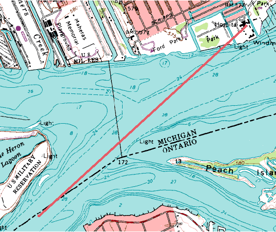
- In 1891, the Jefferson Avenue Railway between Detroit and Grosse Pointe opens.  That same year,  range towers are constructed near Windmill Lighthouse to guide ships traveling down the Detroit River channel.

Two Range Towers
image credit

Aligning the range tower lights from within the Detroit River
Channel (see red line) assured ships that they were centered
 within the channel
image credit
 - In 1892, Mayor Hazen Pingree leads a campaign to remove tolls along travel routes between Detroit and Grosse Pointe.  By 1896, most of the tolls are removed.

- The first structures built in the Grand Marais were two race tracks: The Detroit Driving Club (1894-1911) and the Detroit Jockey Club (1894-1919).  The brick pavers along Marlborough that marked the entrance to the Detroit Jockey Club remain today.  Learn more about these tracks by reading the following blog: The Forgotten Derby Winners.


1900s

- In 1903, the Village of Fairfield incorporates inorder to petition the Township for funds to pave Jefferson avenue.  After a lawsuit, Fairview wins funding.

- In 1906, Jefferson Avenue is paved in bricks and the Fox and Conner Creek bridges are rebuilt. Tolls are removed.

- In 1907, the City of Detroit begins the process of annexing the Village of Fairview amid concern that sewage dumped into the Fox Creek will contaminate the quality of the City's drinking water. Legislation is written and delivered to Lansing in early 1907.  An error in the bill's wording allows Detroit to annex only 2/3rds of Fairview (to Wayburn/Alter).  In May 1907, Grosse Pointe Park quickly forms between Grosse Pointe and the new Detroit border preventing the correction of the error.  In October 2017, Detroit completes the annexation of the remaining portion of Fairview.

Postcard postmarked in 1914 depicting view of the Detroit Motor Boat Club,
Windmill Lighthouse and steel range towers used for guiding ships
(top, center) along the Detroit River
image credit
- In 1907, William Klenk builds a hotel and creates new waterfront housing opportunities by building three canals where the Fox Creek Canal meets the Detroit River.  He creates Klenk and Harbor Islands.

- In 1907, the range towers guiding ships along the Detroit River are rebuilt using steel.

- Between 1913 and 1918, the Detroit Motor Boat Club  (former location of Klenk's hotel) and the General Aeroplane Company shared the lands adjacent to the Windmill Lighthouse.  The General Aeroplane Company would be Detroit's first commercial airplane building enterprise. 

Fox Creek 1917
image credit
- During the 1920s, the community of boathouses and house boats along the Fox Creek Canal at Klenk and Harbor Island continues to grow.

- In 1925, the Fox Creek canal is built.  It runs from the Detroit River to a point north of Jefferson Avenue where the canal flows into underground pipes that run under Jefferson Avenue.

- In 1930, the Fox Creek Backwater gates are built at Jefferson Avenue near Ashland Street to alleviate flooding problems along Ashland Street.  The gates funnel water to an underground sewer which connects to the Connor Creek pumping station.  The design captures storm water north of Jefferson Avenue before it flows south flooding areas adjacent the Fox Creek Canal and the Detroit River.  The gates also forces water from the river to flow towards Jefferson Avenue so that it can be used to flush the new underground sewer.


The Fox Creek as it passes under
Jefferson Avenue
- During prohibition, a period which would last from 1917 to 1933, Michigan becomes the primary entry of illegal alcohol.  75% of all illegal alcohol entering the US comes through Michigan.  This area along the Fox Creek Canal becomes one of many smuggling points.

- In 1930, the ship guiding range lights are removed and a new 125 bed US Marine hospital is built at present day Mariner's Park.  In order to expand the land area, the City of Detroit's Engineering Department fills in submerged portions of the site.
  
Postcard of Marine Hospital and Windmill Lighthouse
image credit

- In 1933, the lighthouse is again torn down and the present standing Windmill Lighthouse is built.

- In the 1940s, using US government incentives to create housing for veterans returning home from the war, Lakeside Trailer Court opens adjacent to the hospital and lighthouse.

Postcard depicting Lakeside Trailer Court
image credit

 - On October 24, 1958, a plane crashes at Ashland Street near the Detroit river.  Six (6) crew members are killed, three (3) homes destroyed, 40 homes damaged, and two (2) women treated for burns: 
The four-engine delta-winged plane was on a training mission, flying from Lincolnshire, England, to Lincoln, Neb.  Crippled, it dived from 45,000 feet, passing over hospitals and schools on its path to the ground. The impact was so hard that searchers dug 70 feet in an unsuccessful effort to find the plane's cockpit.  The largest piece of wreckage found was a 6-foot section of wing that landed on a porch.

Site of plane crash in 1958
image credit
 - Between 1954 and 1960, 70,000 jobs are lost within the greater Jefferson-Chalmer neighborhood.  In addition, between 1970 and 1977, the neighborhood loses 37% of its housing.

- During the 1960s as racial tensions increase, Alter Road becomes a symbolic dividing line between the majority African-American City of Detroit and majority White Grosse Pointe Park.  Physical barriers are built at cross streets preventing traffic from crossing the border. 


The Marine Hospital and Trailer Park grounds in 1949
image credit
- After being converted to a clinic in 1969, the hospital was closed in 1981 with the reorganization of  the US Public Health Service into the Department of Health and Human Services.

- In 1982, the hospital grounds were deeded to the City of Detroit and Marina Park opened.

 2000s

- In 2004, the Lakeside Trailer Court closes in preparation for a proposed high-end housing development known as "The Point at Belle Harbor".  The development never comes to fruition.

-In 2013, the land for "The Point at Belle Harbor" (and the former location of Lakeside Trailer Court) is placed on sale for $3.9 million dollars.  The property includes 400 feet of waterfront and 800 feet of canal frontage.

Mariner Park and the former site of Lakeside Trailer Court today
image credit

-----------------------------------------
Internet Sources:

The Village of Fairview:
Sinacori, Nicholas, Horse Power, Men and Machines, 2012.

Detroit Canals - Far Eastside:

Milk River:

Windmill Point Lighthouse: 

Lakeside Trailer Park and Marine Hospital:

Proposed Jefferson-Chalmers Historic Business District Final Report:

Wise, Jerry, "Windmill Point Light"

Coastal Zone Information Center, US Government Printing Office, "Know you Riverfront Park: A Historical and Informational Brochure"

Richard Bak, "Mayday!", Hour Detroit, July 2008


Wednesday, June 1, 2016

A Pennycress for your Thoughts

How do you return huge swaths of vacant Detroit land to a productive use?  How do you deal with land littered with debris and poisoned by contaminated soils?  How do you return this land to a productive use?   These are questions I've been working on with a team of consultants on Detroit's eastside.

Vacant Detroit lots

According to Detroit Future City statistics, 20 square miles of Detroit's occupiable land is vacant. And according to a report by the C.S. Mott Group at Michigan State University, 7.6 square miles of this land is publicly owned.

More vacant Detroit lots

What if this land was converted back to agriculture?  What would you grow?  What crop would be the most productive? How could it serve as a catalyst for economic development?  For some, the answer lies in Pennycress.

Pennycress
image Credit: Wikipedia Commons

Most consider the arrival of Antoine de la Mothe Cadillac on the shores of the Detroit River in 1701 as the arrival of Pennycress in the new world.   Though its taken some 300 years, many now believe this European stowaway may prove to be the key to renewing Detroit's vacant land.

Below are my Top 5 reasons that make Pennycress the perfect urban farming crop:

Pennycress
image credit: Net World Directory

Reason #1: Phytoremediation

Phytoremediation is a process that use plants to remove toxins from contaminated soils.   It's a method that can be significantly cheaper than the typical "dig and haul" to a landfill technique.

Detroit has a three times higher rate of children with elevated blood lead levels than the national average. It is a primary toxin in cities because of its former use in paints and gasoline.  Urban studies have shown lead levels to be the highest along the perimeter of building foundations and within a few feet of busy streets.
  • Pennycress is known as a hyperaccumulator of heavy metals.  As the plant grows, increasing levels of toxins are stored within the plant's roots and leaves.  These roots and leaves can then be removed along with the toxins they contain thereby decontaminating the soil.

Alpine Pennycress
(Thlaspi caerulescens)
image credit: Wikipedia Commons

Reason #2: The "Street Smart" Flower

Pennycress is especially adapted to survive in the harsh urban environment because...
  • It is considered "native" to Michigan and will not act as an "invasive species".
  • It is a winter annual, meaning that it can be planted in the fall (October).  It will lie dormant under snow during the winter and is harvested in the spring (May).  This allows an alternative crop, such as soybeans, to be grown during the summer months.
  • It has the ability to grow in "marginal conditions", requiring very little if any pesticides.  This is particularly true because of the average low temperatures occurring during its growing season (fall and winter)
  • It will only grow to an average height of around 2 feet allowing it to be planted near roadways without obstructing sight lines.
Biodiesel
image credit: Wikipedia Commons

Reason #3: Biodiesel

When pennycress is crushed, it produces vegetable oil (36% by volume) and meal.  The vegetable oil by itself can be used as a low temperature lubricant.  But more importantly, biodiesel can be produced from the oil through a process called transesterification. The process produces glycerin  (which is used in the production of soap) and methyl esters (the chemical name for biodiesel).
  
Pennycress produced biodiesel makes sense because...
  • It performs at temperatures as low as -28 degrees Celsius (-18.4 degrees Fahrenheit).
  • Unlike corn and soybeans, it is not a food crop and therefore does not compete with the world's food production. 
  • It is ecologically friendly as compared to traditional fossil fuels (emits 78% less CO2).
  • It works within the existing petroleum distribution network
  • Biodiesel blends are warranted in most existing diesel engines and certified by ASTM.
  • The energy yield per unit of input is 3.24 units versus 1 unit gasoline and approximately 1.35 units corn ethanol
  • Its mileage per gallon is roughly equivalent to that of standard diesel fuel.

Animal meal pellets
image credit: Asico Group

Reason #4: Pennycress Meal

As mentioned earlier, when Pennycress is crushed it produces vegetable oil (which is used to produce biodiesel fuel) and meal.  Like other seeds in the mustard family, the meal is high in glucosinolates, which give mustard and horseradish its sharp taste.  Therefore the meal can be used as....
  • A bioherbicide if the glucosinolates it contains are used in high dosages (an alternative to methyl bromide which is used in high value crops such as strawberries)
  • A fertilizer containing about four percent nitrogen and 0.7 percent phosphorus
  • An animal feed, though glucosinolate levels need to be monitored.  This is important to note because feedstock can account for more than 70% of the cost of producing biodiesel.
A biodiesel fuel pump
 (The "B" indicates the percent
biodiesel, i.e. B20 is 20% biodiesel,
80% petrodiesel)
image credit: Grow Pennycress

Reason #5: Job Creation

Because of how simple pennycress is to grow, it could serve as the spark that generates economic development in communities in search of new investment and job creation.  More specifically...
  • Local residents can be taught to grow the plant.  
  • Seeds require a very shallow planting depth meaning they can be spread by hand.
  • Ongoing studies indicate that pennycress will produce a 35% higher earning per acre as compared to other oilseed and grain crops.
  • Locally produced biodiesel fuel keeps the energy revenue within the community in which it is consumed
A vision for a new Detroit "Green Thoroughfare"
image credit: Robert Saxon, Jr. AIA

What's Left to Do

As promising as Pennycress appears, there still remain many hurdles.  Issues include:
  • How vacant lands will be assembled into acreages that produce seed in volumes that will make biodiesel production profitable?
  • Can a distribution network be assembled that integrates with the existing petroleum based system?
  • Can biodiesel refinery equipment be assembled and made accessible to scattered pennycress farms?
  • Can a system for training and maintaining land before, during and after seed production be developed?
Only with time, patience and effective experimentation, will Pennycress reach its potential as the urban homesteader's most profitable crop.

_____________________

Grow Pennycress, Arvens Technology, Inc.

Start Detroit, MetroAG Services

Pennycress: Up and Coming Low Break-Even Cost Crop for the Prairies, Start Detroit

Rolfe, G.L., A. Haney, and K.A. Reinbold. 1977. Environmental contamination by lead and other heavy metals. Vol.2. Ecosystem Analysis. Institute for Environmental Studies. University of Illinois, Urbana-Champaign. 112pp.

Singer, M.J. and L. Hanson. 1969. Lead accumulation in soils near highways in the Twin Cities metropolitan area. Soil Science Society of America Proceedings 33:152-153.

Schill, Susanne Retka , "Making Pennycress Pay Off", Biodiesel Magazine, January 17, 2008.

Friday, February 19, 2016

From Accra to Kalamazoo

Part 13 of 13 in our journey from Timbuktu to Kalamazoo    
(Connecting Landmarks in Michigan and African History)


I am still convinced that nonviolent resistance is the most potent weapon available to oppressed people in their struggle for freedom and justice.  There is power and real power in this method. First it has a way of disarming the opponent. It exposes his moral defenses. It weakens his morale and at the same time it works on his conscience. He just doesn't know how to handle it. – Dr. Martin Luther King, Jr. at Western Michigan University, Dec. 18, 1963


In the summer of 1963, during the local National Association for the Advancement of Colored People's Youth Council summer job campaign, three African-American teenagers walked into a white owned pharmacy hoping to find summer employment. David Johnson, president of the local NAACP youth chapter, Walter Jones III, the group's vice president, and Lois James, the group's secretary, each requested a job application from the store Owner's wife, Mary Jean Van Avery. They were refused. They would be the only store to refuse to take applications.
The Van Avery Pharmacy was opened in 1935, which at that time was a solidly Dutch neighborhood, but by the early 1960s, the neighborhood's population was being transformed into majority African-American. As a Kalamazoo native, Donald Van Avery had never refuse to serve his Black customers, however, he had also never hired one. After visits from adult NAACP officials, Mr. Van Avery refused to change his position.

The picket lines went up on June 17, 1963.

The Civil rights movement had reached Kalamazoo, Michigan. After three weeks of picketing, the pharmacist signed an agreement with the NAACP. The boycott however continued until Van Avery hired his first African-American employee.

Van Avery Pharmacy (1951)
The store was sold a year later, but reverted to the Van Avery's after the death of the buyer. It closed permanently in 1967. The building was later occupied by the Powell Branch Library, which stayed there until it moved in 1985. The site is now the home of the Northside Ecumenical Senior Center.

But back in 1963, the same year as the boycott, Dr. Martin Luther King, Jr., on December 18, would make an historic speech at Kalamazoo's Western Michigan University. The topic of his speech was appropriately titled "Social Justice."

Dr. Martin Luther King, Jr.
Memorial in Kalamazoo, MI
In 1989, to commemorate his visit, a statue of Dr. King was erected in Kalamazoo's MLK park. Sculpted by Lisa Reinertson, the monument animates a slightly larger than real life Dr. King by depicting him striding, his eyes fixed forward, in a long flowing robe. The robe is adorned with scenes from the civil rights struggle. A black slave laboring in a field, a Montgomery city bus and a portrait of Rosa Parks, the Selma to Montgomery march, the bars of the Birmingham jail and a North Carolina lunch counter to name a few. As written by art historian Michael Panhorst, "The monument is an appropriate reflection of the man and the struggle for civil rights that was his life's work. King wore the mantle of the movement in life and his bronze posthumous portrait is shrouded with scenes of that struggle."

Dr. Kwame Nkrumah Memorial
in Accra, Ghana
In a park named Independence Square, within the heart of the city of Accra, Ghana, another bronze statue stands in memorial to a man Dr. King would meet in his only trip to Africa in 1957. The occasion was the inauguration of Dr. Kwame Nkrumah as Ghana's (formerly the Gold Coast) first black African prime minister. The first African nation to declare its independence from British Colonial rule, Dr. Nkrumah would be the first to lead the new nation.


I can remember when Mrs. King and I first journeyed to Africa to attend the independence celebration of the new nation of Ghana. We were very happy about the fact there were now eight independent countries in Africa. But since that night in March, 1957, some twenty-seven new independent nations have come into being in Africa. This reveals to us that the old order of colonialism is passing away, and the new order of freedom and human dignity is coming into being. – Dr. Martin Luther King, Jr. at Western Michigan University, Dec. 18, 1963

Dr. Kwame Nkrumah

At midnight on March 6, 1957, on the same spot that his memorial now stands, Dr. Kwame Nkrumah announced Ghana's independence from colonial power. He would be a leading advocate of Pan-Africanism, a movement seeking to unify African people into a unified community. He would be a founding member of the Organization of African Unity. He would remain in power until a coup in 1966 forced his flight to Guinea. He would never return to Ghana dying in exile in 1972.


Dr. Nkrumah Memorial
That same year, a young Ghanaian architect named Don Arthur was in London, on break from his doctorate studies in Moscow. The idea of creating a memorial park was born when a letter authored by the African Students Union in London was sent to Guinea requesting that the body of the late president be returned to Ghana. It would take 24 years for the idea to come to fruition.

Dr. Nkrumah Tomb
The park attempts to blend the design elements of six monuments: India's Taj Mahal, France's Eiffel Tower, Egypt's pyramids, Babylon's Hanging Gardens, Berlin's Alexander Tower and Moscow's Mausoleum for Lenin.

One enters the park flanked by two reflecting pools, fed by kneeling pipers that entertain you as one paces 100 steps to a bronze statue of Dr. Nkrumah. Just beyond the statue sits the mausoleum which rises five stories in the shape of a truncated tree stump and symbolizes Dr. Nkrumah's incomplete vision for Ghana. Within the marble clad mausoleum, one finds the tombs of Dr. Nkrumah and his wife, Fathia.
Dr. Nkrumah Museum Frieze
Beyond the mausoleum, one passes over a drawbridge to arrive at a semi-subterranean museum faced with a white frieze dedicated to Fathia. The frieze incorporates traditional Ashanti symbols known as Adinkra. The museum exhibits a collection of photos, capturing moments in Dr. Nkrumah's political life. In the pictures of Dr. King and Dr. Nkrumah meeting, the symbolic connection between the struggles of African-Americans and Africans takes physical form.


University President James W. Miller
& Dr. King speaking a Western
Michigan University (Dec. 18, 1963)
During Dr. King's speech in 1963, he recognized the world was becoming flat. He repeated comedian Bob Hope's joke that in flight from Los Angeles to New York City, one could "hic" in LA and "cup" in New York. But more importantly, he spoke about living in a world where the diminishment of one man diminishes the achievement of mankind.
 
Dr. King and Dr. Nkrumah
meet in Ghana (1957)
As I look at pictures of Dr. Nkrumah, I can't help but see myself. I can't help but literally see his physical features in myself. And it makes me wonder if, by reading about his struggles, if his intellect and spiritual strength is also within me. There is a confidence to be found in seeing people that look like me achieving. And it generates a strength to find the best within me.
  
In Dr. King's words on that night in 1963 at Western Michigan University,

It is simply this, that through our scientific genius, we have made of this world a neighborhood. Now through our ethical and moral commitment, we must make of it a brotherhood. We must all learn to live together as brothers or we will perish together as fools. This is the great challenge of the hour. This is true of individuals. It is true of nations. No individual can live alone. No nation can live alone.

This is why I believe it's important to shed light on African history, especially to young African-Americans, for there is strength to be found this history. And through this strength, not only an individual, but a people, a nation and mankind can be uplifted.

Thursday, February 4, 2016

From Sun City to the Motor City

Part 12 of 13 in our journey from Timbuktu to Kalamazoo
(Connecting Landmarks in Michigan and African History)


Palace of the Lost City
Centuries before tall ships were ever dreamed about and long before the dawn of a western civilization, nomadic people from northern Africa set out to seek a new world. Eventually they found a land of peace and plenty in a secluded valley, shaped by an ancient volcanic crater. The Gold these people mined brought them great riches and they built a mighty palace for their benevolent king, whose hospitality became renowned throughout Africa.
Palace of the Lost City


Sun City Resort

Billionaire developer Sol Kerzner's Sun City Resort was constructed for $260 million. It sits in the South African Northern Province in a region established by the former apartheid government as the black independent homeland called Bophuthatswana. Designed by the late American architect Jerry Alison, it reflects his and his design team's substitution of a fictional legend for local heritage in finding inspiration for the buildings they designed. As Louis Gates, Jr. explains in a conversation with Alison, unlike most other places he had worked at, such as Malaysia, "this area of Africa didn't have much of a heritage."

But on a terrible day an earthquake destroyed their homes, aqueducts, fields and mine shafts, sparing only the palace on its foundation of rock, and the people fled. Vegetation slowly concealed the ruins and all that remained was a memory, the legend of a Lost City… until 1991 it was "rediscovered" at Sun City and restored to its former splendor by the following year.

The 28 Legends of Sun City

The Bridge of Time
The four hotel complex is designed based upon twenty-eight fabricated legends related to each site at the resort, with the Palace of the Lost City at its heart. The palace is surrounded by the largest man-made forest ever created, complete with imported trees. Monkey Springs Plaza is designed based upon the story of monkeys that saved the village during a drought by going to the treetops to gather juice for the village people. The Bridge of Time shakes every hour to commemorate the disastrous earthquake that destroyed the "ancient ones". At the Valley of Waves, swimmers drop just over 55 feet down a chute from the Temple of Courage before splashing into the pool below. And boat rides are offered along the Lazy River.
Valley of Waves

The most painful aspect of Dr. Gate's story is his brief survey of tourists staying at the resort, who nearly all thought the designer's imaginary legends to be true. And to add salt to the wound, a few hundred miles away, lay the ruins of the Great Zimbabwe, believed to be the capital of the Shona Empire. Nearly 1,000 years old it was only discovered some 70 years ago. And yet, for the typical South African remains unknown.
Gary Player Championship
Golf Course

The true history of African people must not only be studied and reconnected with its descendants, but must also overcome popular pre-fabricated stories devoid of any fact, but sweeten with enough mis-information to make people believe them. As amazing as the architecture may be at Sun City, for all the riches it may generate for its owners, for all the tourist it may bring to South Africa, I can't help but believe that for the cause of raising people's awareness of sub-Saharan history, it is doing more harm than good.

1985 Sun City Boycott

Sun City is best known to Americans through the 1985 apartheid protest song. The collection of singers and actors who recorded the song pledged to refuse any and all offers to perform at the resort's Super bowl. Though the laws and physical barriers of apartheid have since been removed, the legacy of replacing the lies of African inferiority remains to be overcome. It is the same legacy that slavery has left for African-Americans.

Casinos come to Detroit

Wagner Bakery
Desperate to attract new sources of tax revenue, US cities began to grapple with the legalities of building casinos. For Detroit, the idea became earnest in the 1990s. And with the approval of Proposal E in 1996, the idea came to fruition when three casinos were licensed for construction. Motor City is the only locally owned casino and appropriately chose for its location the site of Detroit's Wagner Bakery, abandon since the 1970s. Unlike its competitors, it decided to incorporate the existing factory building into its new design. And unlike the Sun City Resort, its designers decided to blend the site's true history with the making of its future.

The Wagner Baking Company 


Continental Baking Company was founded as the Ward Baking Company in New York City in 1849. In 1921 William Ward, grandson of the company's founder, formed United Bakeries, which was renamed Continental Baking in 1925. In 1924 Continental
Baking acquired the Wagner Baking Company of Detroit, and in 1925 Continental Baking bought Taggart Baking and became the largest bakery in the United States. The company's products were sold under two widely advertised trade names: "Wonder" for its bread products and "Hostess" for its cake products. And in 1933, Continental Baking introduced to the world Hostess Twinkies. The original factory complex was designed by Walter W. Ahlschlager, who would also design two of the grandest buildings in the country in the late 1920's: New York City's "Cathedral of Motion Pictures" Roxy Theater and Cincinnati's 49 story Carew Tower.

Motor City Casino

Motor City Casino
Designed by Michigan architects Giffel/Norr with the help of hot-rod designer Chip Foose, the reborn building was completed in 2007 and meshes the old factory with the sleek and stream lined design of the 1957 Chevrolet Bel Air, suked up with tail fins and chrome detailing. The hard corners of the brick factory are softened with aerodynamic metal panels that swoop along the building's cladded sides, cutting through the wind like the cars zooming along the Lodge Freeway below. At night, movement is again expressed through neon lights flickering in choreographed patterns along its elevation like the flickering high beams of a hot rod's headlights, looking for attention while cruising along Woodward Avenue.
1957 Chevrolet Bel Air

At times the clash between the weathered brick and modern metal panels can be abrupt and clumsy. But the overall idea of creating a hot rod out of an old wonderbread factory comes through louder than a Buick revving its 300 horsepower engine. I believe the design breathes new life into a once forgotten building. And instead of ignoring its history, pays respect to the past and creates something new.

Conclusion

New Housing in the
Shawdow of Motor City
With so many lifeless Detroit buildings, Motor City stands as an example of the architect melding an old spirit with the new life he or she breathes into it. Like a grandchild listening to stories told by her grandmother, the building speaks to a past as well as to a present. A rejuvenating architect uses an understanding of original intentions to create new innovative and unique solution. They allow the ghosts of the past to harmonize with life in the present.

But one shouldn't let the architecture blind one to the project's true goal.  Though we can easily debate the success of the architecture, it remains to be seen whether the project can breathe new life into its declining surrounding community.